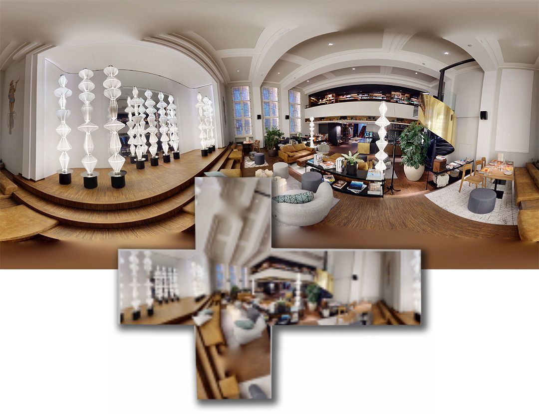
Native 16K Panoramas from Matterport Projects
The Industry Standard for Self-Hosting & Archiving. Precision Leveled. Relative GPS Positioning.
Matterport sets the industry standard for capture speed and quality. Dimension3 allows you to utilize that high-fidelity data beyond the cloud ecosystem.
We convert your proprietary project data into open, universal assets—empowering you to build sophisticated experiences with professional tour building software or create secure, independent archives.
Why this matters
Matterport is an efficient and widely adopted platform for capturing and presenting spatial data.
This service focuses on delivering high-quality panorama outputs that can be used independently of any specific platform.
This service adds two critical qualities that are rarely available elsewhere:
-
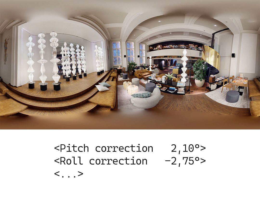
Perfect leveling – panoramas are corrected using capture orientation data, not visual estimation
-
Consistent positioning – all scans are spatially aligned as a group, not treated as isolated images
Together, this enables workflows that would otherwise require extensive manual correction or are simply not feasible.
Formats & Features
Leveled Panoramas (Pixel-Baked)
Perfectly leveled panoramas with pitch and roll correction applied.
Ready for any viewer or archive use.
Metadata-Based Leveling
Orientation data embedded in EXIF metadata.
Displayed leveled in compatible tools without altering image data.
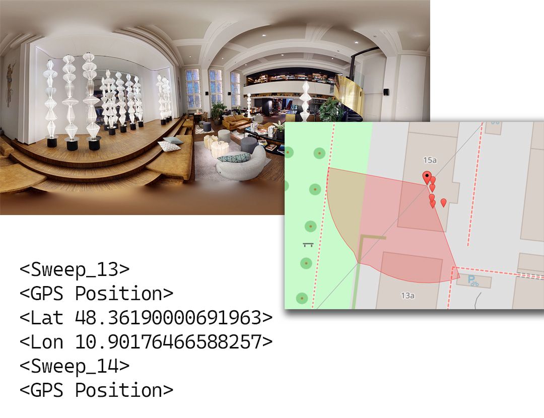
Spatial Positioning
Relative scan positions and heading orientation included.
Ideal for tour builders and Street View preparation. Included in all packages.
Technical Advisory
Our service operates strictly via authorized administrative transfer.
We process the Native Source Data (134 MP). Our conversion engine preserves the full resolution and dynamic range of the original capture, delivering high-fidelity 16K JPEGs optimized for professional use.
Note: Our 12K performance panoramas are downscaled from native 16K.
Secure. Authorized. High-Fidelity.
Engineered for Professionals
Our datasets include coherent spatial metadata, ensuring the scan constellation remains intact. This enables instant 'Auto-Connect' workflows and automated hotspot placement on floorplans.
TYPICAL USE CASES
The image sets can be used for:
-
Creating virtual tours with tools such as Pano2VR, 3DVista, or similar software
-
Hosting tours independently, including offline or restricted environments
-
Preparing high-quality Street View workflows using third-party editors
-
Long-term archival of 360° documentation in standard, future-proof image formats
-
Construction and installation documentation before areas are closed or finished
-
Property handover documentation in commercial and institutional projects
The Technical Difference
Why professional workflows rely on Authorized Conversion.
| Feature | URL-Based Services | D3 Native Conversion |
|---|---|---|
| Source Data | Web Player Stream | Native Source Data |
| Resolution | Often Interpolated | True 16K (134 MP) |
| Image Quality | Web Streaming Quality | Archival (High-Fidelity) |
| Geometry | Prone to Tilt | Precision Leveled |
| Ownership Check | None (Public URL) | ✓ Strict Chain of Custody |
| Process | External Access | ✓ Authorized Transfer |
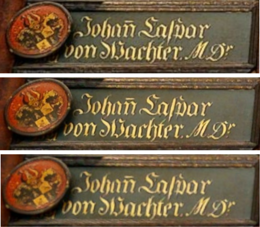
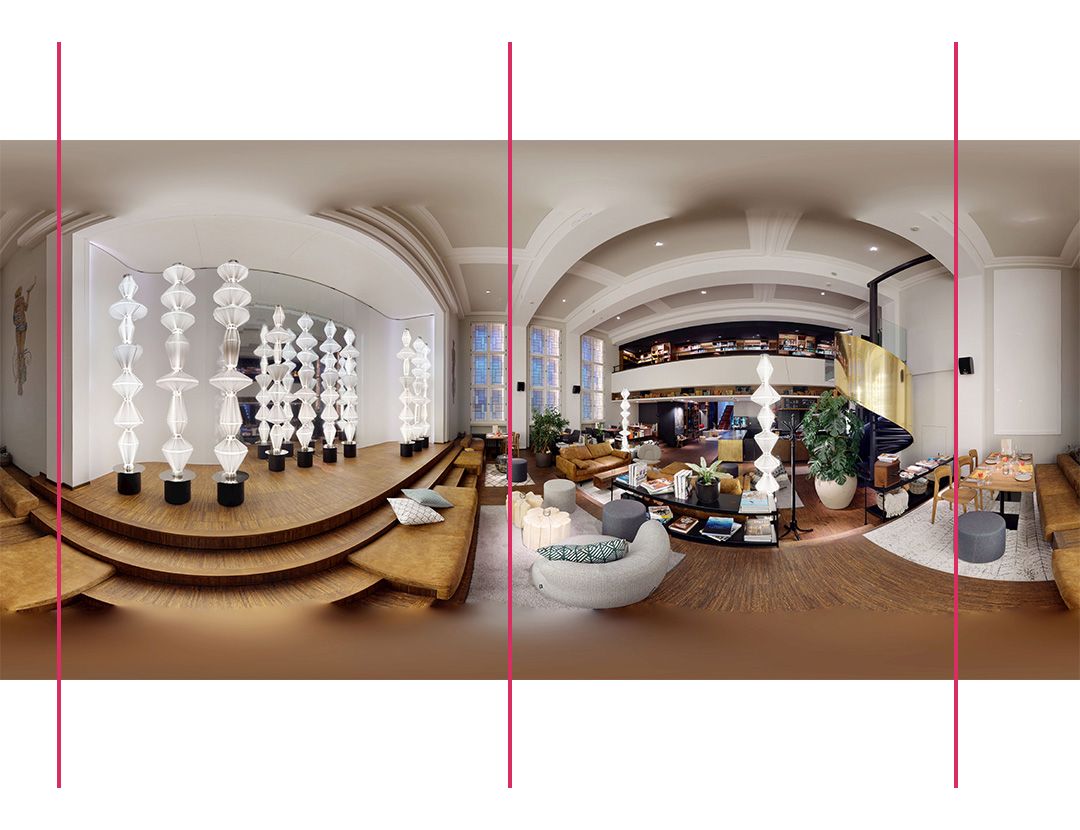
Image quality comparison (massive zoom)
1. Matterport online (compression artifacts)
2. Native 16K panorama export
3. Matterport Workshop 8K download (blurry)
🔍 Seeing is Believing
Don't take our word for the quality. Use our High-Fidelity Validator 360° Panorama-Viewer to inspect native 16K samples in your own browser. No upscaling, no sharpening, just raw 134 MP clarity.
Sample Dataset
See sample output before you order.
To make evaluation easier, a real-world sample dataset is available for download.
It includes high-resolution panoramas in different formats and a short video showing how the data can be used in practice.
Chain of Custody
Zero impact on your live projects. We operate exclusively on a Duplicate of your project. This ensures your active tours remain 100% untouched and online. The transfer of this duplicate acts as the ultimate proof of ownership, strictly maintaining the legal Chain of Custody.
1. Create a Duplicate
Inside your Matterport dashboard, create a copy of the project you wish to convert. This strictly separates the processing data from your active tour, ensuring your original project remains 100% online and untouched.
2. Authorized Transfer
Transfer only the duplicate to our secure admin account. Note: This requires Admin privileges, verifying that you are the legitimate owner of the data.
3. Processing & Removal
Our engine processes the Source Data from the duplicate. Upon delivery of your 16K assets, the project copy is permanently deleted from our system (or transferred back upon request), ensuring strict data minimization.
Available Panorama Resolutions
Depending on your intended use, we provide different output resolutions.
All resolutions are generated from the same source data. The difference lies in file size, performance, and how the imagery can be used over time.
16K (16384 × 8192) native resolution
Maximum resolution for archiving, documentation, and high-end virtual tours.
Designed for long-term use cases where detail retention and future compatibility matter.
12K (12288 × 6144) Ideal for high-performance web hosting and professional virtual tours.
Our 12K panoramas are downscaled from 16K native resolution sources to provide a razor-sharp image with significantly shorter loading times in web-based viewers.
Ready to get your images?
Choose your product, resolution and project size to order.
We take care of the technical workflow.
Product Selection
Forensic Archive
Starting at $299
16K Native Resolution • Pixel-Baked
Best For: Construction (BIM), Litigation, Insurance, Long-Term Archiving, High-End virtual Tours.
Description: The ultimate universal file. 16K pixels are permanently leveled ("baked") to ensure compatibility with any image viewer or software—forever.
Features:
-
✅ 16K Native Resolution
-
✅ Pixel-Baked Leveling
-
✅ GPS-Ready Metadata
-
✅ Software Independent
⭐ Production Master
Starting at $229
16K Native Resolution • EXIF-Embedded
Best For: 3DVista & Pano2VR Pros, High-End Marketing, Museums.
Description: The raw "Digital Negative." Uncompressed 16K native sensor data. Uses metadata for leveling to preserve 100% of original pixel integrity.
Features:
-
✅ 16K Native Resolution
-
✅ EXIF-Embedded Geometry
-
✅ GPS-Ready Metadata
-
✅ Zero Generation Loss
Performance Standard
Starting at $189
12K Resolution • EXIF-Embedded
Best For: Virtual Staging, Residential Real Estate, Hotel & Hospitality.
Description: Optimized 12K resolution (downscaled from native 16K sources) for maximum playback speed on mobile devices and VR headsets. The perfect balance of sharpness and performance.
Features:
-
✅ 12K Resolution
-
✅ EXIF-Embedded Geometry
-
✅ GPS-Ready Metadata
-
✅ Fast Loading / Web Optimized
PERFORMANCE STANDARD 12K - Project Size Selection
You have chosen the Studio Standard. 12K Resolution • EXIF-Embedded Geometry • GPS-Ready.
Instruction: Please check the total number of scan points in your Matterport project and select the matching tier below.
⭐PRODUCTION MASTER 16K - Project Size Selection
You have chosen the Production Master. 16K Native Resolution • EXIF-Embedded Geometry • GPS-Ready.
Instruction: Please check the total number of scan points in your Matterport project and select the matching tier below.
FORENSIC ARCHIVE 16K - Project Size Selection
You have chosen the Forensic Archive. 16K Native Resolution • Pixel-Baked Geometry • GPS-Ready.
Instruction: Please check the total number of scan points in your Matterport project and select the matching tier below.
DATA HANDLING
Project data is used exclusively to generate the ordered deliverables. After delivery, all project data is deleted in accordance with our data handling policy.
You are responsible for ensuring that you have the right to submit the project for processing. Never transfer original projects, create a copy.
CONTACT
If you have questions about scan selection, project size, or device compatibility, please contact us before placing an order ([email protected]).
